Lexington Battle Green

Distant memories of the battles of Lexington and Concord reside deep in the hearts of public consciousness in the United States. Images of Revere and Dawes galloping through their famed midnight ride, the minutemen emerging fresh from the tavern to face the oncoming British, are conjured as an epic moment of heroism, however exaggerated some of these stories have become in the centuries since that pivotal time period. As someone who did not grow up in New England, visiting a place like this feels like entering a dream, treading upon sacred ground in which what once seemed like a fictional story becomes reality. Even with all of our current societal focus on the ills our country has perpetuated, everything that happened in this place has led us to this point, in a country that is hopefully continuously striving towards those strong ideals voiced by the nation’s founders.

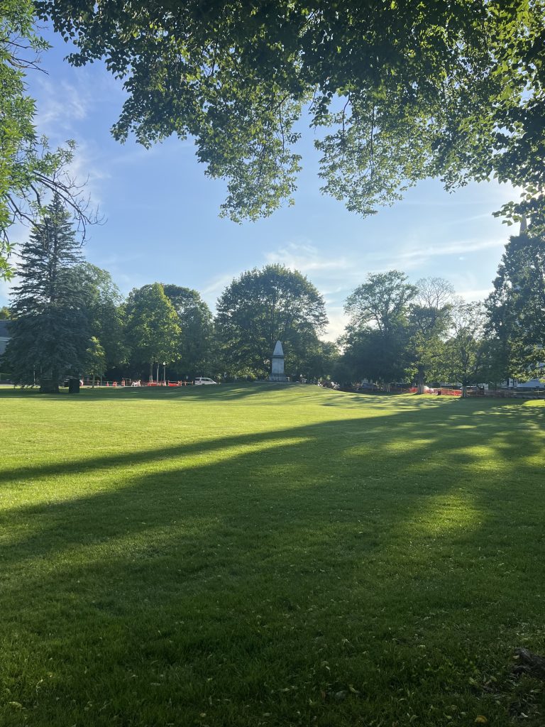
As a child, I imagined this place to be a massive battlefield of epic proportions, perhaps influenced in my mind by some war movie showcasing thousands of men lined up in battle formation. In reality, the Lexington Battle Green is a fairly small park, a modest triangle of perhaps a few acres. It won’t take too long to walk around the entire place, even if you do stop to read the signs!

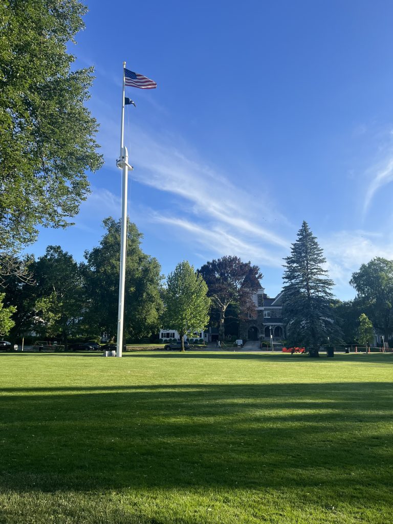
There are a few points of interest to note here. As what is essentially a war memorial, there are several monuments around the green dedicated to the event. The most visibly prominent is the central flag pole, dedicated on the 200th anniversary of the battle here and permitted to fly the American flag 24 hours a day, a rarity in public spaces. Secondary to that is the minuteman statue in the south eastern corner of the park, originally meant to be a generic representation of a minuteman, now seen as a symbol of their general, John Parker, who fought in the battle with mere months left to live after contracting tuberculosis. On the southwestern side of the park, a memorial burial site contains the remains of some of the fallen soldiers from that fateful day.

As a traveler, you will likely get the most out of this experience if you have some interest and recall of the history associated. The park itself is small, and aside from some very mature local tree varieties like maple, the park is not a natural paradise. For those interested in nature walks instead, there is a quite famous rail trail just north of the green. Plan to fill your day with other stops, such as museum visits, shopping or dining in downtown Lexington, if you are making a day trip here.

Parking availability may vary on the day but there is a decent amount of free two hour street parking. Unfortunately there is no train from Boston to Lexington directly, so you will need to transfer from the Red Line to a bus if you are coming from the city on public transit.

North Reservoir, Middlesex Fells Reservation

,

North Reservoir, Middlesex Fells Reservation

Early June in New England can be a rainy affair. For those who don’t like the cold, outdoor activities might feel like a chore, but some benefits come from visiting local nature reserves when the weather is dreary. The New England forests near Boston are normally awash with mosquitoes and other insects during the warm summer months, but many of these creatures will seek shelter to avoid getting hit by raindrops during summer storms. It was during such a weather event I visited the northeastern portion of the Middlesex Fells Reservation north of Boston to find some points of interest located in the park. Amazingly, I only saw a single mosquito the entire hike!

There are two points of interest located on Google Maps near the North Reservoir, neither of which are true showstoppers but are nice to look at if already in the area. The first is the North Reservoir Lookout. There’s not really a defined point here as you can see the reservoir from various locations, but the point marked on Google Maps provides somewhat of a view of the dam containing the water source of the Western side.

It’s unclear based on online photos whether the dam used to be open for walking, but the current path directs hikers below the dam to cross to the other side, which obscures the views for a bit and is not a very exciting stretch of path. Nevertheless, you can see some historic structures here that seem to still be in use for reservoir maintenance.

The views of the water itself can be stunning. Even on this rainy day the surface was wafting with a calming mist that hovered near the surface an blew upward as the wind picked up.

The second portion of the hike I took brought me to a small boulder called the rock sofa, a surprisingly comfy rock with a dip in the side where you can sit to take a break from walking.

It’s a cute name and an obvious landmark on the trail, but the trails to get there are not always clearly marked so you need to stay closer to the water to find the rock.

The trees in this area during this time of year are beautiful, consisting of maples, white pines, and beeches, the coloring of the deciduous tees almost to their green summer peak but still have a slightly translucent look to them, allowing the soft cloudy light to filter in through the canopy and making for great photo lighting. Whether you need to go to this particular spot to get this vibe is debatable, but the maintainence of the park and mix of shoreline and white pine forest allows for easy treking compared to more dense portions of local forest, and also may help cut down on the number of insects in the park.

It’s a great location for an easy day hike if you have a car and can drive to one of the entrances at the northwest portion of the park. You may need to Street park on the nearby neighborhood roads if you stop at an entrance that doesn’t have a parking lot.

Whip Hill Park

,

Whip Hill Park

Among many estates donated to governments for use as public land is Whip Hill Park in Stoneham, Massachusetts. Unlike Stonehurst in nearby Waltham, MA’s Storer Conservation Area, the manor at Whip Hill is a relatively new structure to be preserved as a public site, built in 1930. The owners, the Crocketts, made their fortune in the local rubber industry. Sometime after James Crockett’s death, his wife Angie donated the land and family home to the town in 1968. The historical significance of the site is somewhat limited to this story, but the home is a beautiful manor built in the constantly revived Tudor style. It has since been primarily used for employee housing and is only open for holiday events, but is still nice to look at from the outside!

The land nearest the house is surrounded by what appear to be planted rhododendrons and other shrub varieties, somewhat resembling the landscaped private mansions of Massachusetts today. However, the further you get from the house, the more the native forest of Massachusetts begins to take over the park, culminating in the relatively wild state of the next door Middlesex Fells Reservation, which is directly accessible via connected trails.

Near the home and the parking lot sits a small swampy pond, which seeps into the nearby ground and freezes over in the winter. Views of the pond are accessible on three sides. Interestingly most maps of the site, including Google, don’t show this pond, but it sits directly west of the lot. In addition to this discrepancy, many online maps don’t show the local trails either. Luckily the site is relatively small, making it difficult to get too lost in the woods, and many of the adjacent Middlesex trails are more clearly documented.

Despite its proximity to a busy highway and various neighborhoods, the park is extremely tranquil and calm, particularly in the winter when I visited. The air is still and quiet, and only by listening very closely can you make out the small hum of cars on Interstate 93. It’s an incredible oasis from the surrounding bustle.

The park is named for the nearby Whip Hill, whose peak sits in Middlesex Fells. There are some interesting maps of the location, some of which show two peaks called Whip Hill, one in the estate park and one in Middlesex Fells. It’s unclear if these two peaks are considered part of a single hill or not.

Going to the tops of hills in this area is often fascinating because of the dwarfing effect seen on trees at the top elevations. Whip Hill’s taller summit is no different in this regard. The top is dominated by old glacial rocks that are often seen at these elevations, and the trees become more shrub-like in the areas where they grow around breaks in the rock surface. This is in part a consequence of the lack of soil availability in these areas.

This park is a great destination for anyone living in the area who wants to escape the city for a bit, as well as those with a fascination for Tudor architecture. Nature enthusiasts will also enjoy checking out the hill-based variations in the local ecosystem. It is perhaps not a showstopper for your general tourist population, but a nice nature park nevertheless. There is an onsite parking lot a short walk from the mansion. There may be mosquitoes in the summer and some snow and ice on the ground in winter, so be sure to plan accordingly and bring bug spray and winter footwear as needed. Spring and fall provide the mildest conditions for hiking in this area.

Salem Beverly Waterway Canal

,

Salem Beverly Waterway Canal

UPDATE: As of March 2023, it’s unclear if the parking lot at the southeast tip of the canal is still accessible by car based on updates by Google maps users. Visitors may need to access this area via the High Street Canoe Launch or other Topsfield Linear Common access points.

Outdoor activities in Massachusetts can be a hit or miss in the summer as compared to drier climates out west due to the proliferation of greater numbers of insects, ticks and mosquitoes being the greatest nuisances. Sick of worrying during my outdoor treks after seeing yet another beware of ticks sign, I started seeking out locations with a bit of human curation that would drive large populations of these species away. Untamed grasses are areas ripe for insect activity, so one fantastic location you can visit without worrying too much about whipping out the bug spray is the Salem Beverly Waterway Canal. Due to the active usage of this waterway, grass and trails are carped away on each side of the canal to ensure maintenance access. The space is also open for public enjoyment.

Simple, clean canal

Another fantastic feature of the canal is the kayak access right near the parking lot. The water itself is very calm and a perfect location for beginner kayakers to try out their skills without worrying about underlying currents; for beginner kayakers on calm waters like this, I recommend the smaller 7-foot kayaks available from Pelican. They are not only cheaper than other kayaks but can even fit inside of some SUVs. Inflatable kayaks may also be a good option for those who don’t want to deal with a large plastic kayak and the water area is not too deep, active or wide, as is the case in the canal. This water calmness seems to stem from the mechanisms passing water from the natural Ipswich River into the canal itself. The one downside to this location over natural alternatives is the less interesting change in visuals and you wade down the canal. The system is very straight and somewhat monotonous until you reach the Ipswich River, at which point other challenges start to appear, such as shallow sand banks and dead ends. You will start to see fishing activity in this area as well so watch out for fishing wires!

Plaza de Mayo

,

Plaza de Mayo

The seat of government takes on a new hue in Argentina. A beautiful amalgamation of European architecture and Latin American color, Casa Rosada sits in the heart of the country’s largest city and capital, Buenos Aires. While it’s a challenge to observe parks in a truly natural state in this old, massive metropolis, the designed parks give us a glympse of what may thrive in the natural Pampas grasslands of the region and intertwine these touches of nature with a deep sense of culture and history. Plaza de Mayo is one of many such parks that dot the city, engulfed in a sea of architectural masterpieces that give the feeling of being in Paris or Vienna.

Casa Rosada

The most obvious clue as to the differing continents are the lanky palm trees that line the park, serving as silent, organized bystanders to monuments and statues. It’s unclear to me how prominent Palms are in the natural environment here, as grasslands naturally maintained by wildfire historically dominated the inland areas of the Humid Pampas ecoregion, and the coastal areas of the city are no longer in a natural state. There are otherwise a variety of small shrubs and grasses organized meticulously around lampposts in the grand square.

The most prominent Monument, known as the May Pyramid, hearkens recollections of the Washington Monument in DC, as well as similar pyramid-style monuments in other areas of the city. The monument is dedicated to the historical revolution to gain independence from Spain, hinting at the tumultuous political history of the nation. The overall political nature of this park is extremely apparent in the armed guards surrounding the nearby palace, and the makeshift Covid monument draped around a much older statue directly facing the seat of government. Concerns with how the pandemic was handled stirred controversy here, a place already mired in economic troubles. The historic difficulties are a continuing source of weekly political protests on the other side of town. Nevertheless, this is a safe area for travelers and is popular with tourists.

A makeshift monument fenced off

If you are traveling here internationally, you will need to take a shuttle or taxi from the airport into the city. Some hotels will provide a shuttle service if requested. Once you are in the city, you will be able to utilize public transit via bus or subway. However, as of mid-2022, subway cards are very difficult to find due to a plastic shortage. The most likely place you will find a subway card is inside the local lotteria shops. While there I was unable to find a working kiosk for printed tickets in the subway stations, and without the card you have to pay exact cash in the bus. You can also have your hotel book taxis for you to ensure you are getting a safe option.

Despite some of the transit challenges, as a visitor from the United States this area is absolutely worth a visit. It is rare to encounter such stunning architecture in the States, and Argentina comes with the benefit of little to no time zone transfer and a an exchange rate pertpetually favorable to Americans. The natural environment is perhaps somewhat comparable to Florida winters but slightly chillier in my experience, so remember to bring a jacket!

Storer Conservation Area

new england

Close to the edge of the Boston Basin stands an old mansion in a wooded estate. It’s a picturesque scene for a wedding and is, in fact, open to such events. This old estate sits very close to Waltham’s happening Moody Street and is very accessible to suburb dwellers west of Boston.

The mansion, known as Stonehurst, was owned by Robert Paine, an ethical capitalist rare in his day who came of age during the civil war. Now owned by the city of Waltham, his former home is open to public tours during non-event days. His grounds are also now open to the public on any day.

Closer to the mansion and in the nearby woods you will see a plethora of planted flora varieties leftover from the mansions heyday, such as rhododendron. Go southeast of the mansion and you will find a variety of tree enclaves. Oaks dominate the high grounds while beech trees occupy more of the surrounding slopes. White pines, often young, are scattered throughout the property, and were in fact one of the types of trees used to build the mansion. Look on the displayed maps for abandoned tennis courts; if you follow the route you will find the old fence partially standing next to what appears to be a massive beech tree, its malleable smooth bark carved with initials over the years. I have never seen such a huge beech tree and for that alone visiting this site was worth it.

Be wary that some of the trails are not well marked and it’s somewhat easy to find yourself off of the path accidentally. This was especially the case in late October when the downed leaves covered the ground completely. Luckily, the park is small and not very remote so if you do get lost, it’s fairly easy to find your way back to the main trail. Overall, the terrain to the north is nice and flat for an easy stroll. Be prepared for a lot of roots and some smaller slopes if you head south. It’s a largely non-strenuous hike but it may help with your footing to have hiking shoes in that direction. I was unfortunately wearing rather non-grippy sneakers and found myself slipping quite frequently on the falling leaves. Had I realized the dangers I would have brought my high quality hiking boots!

If you want to get to Stonehurst from Boston via public transport, you will need to take bus 70 to downtown Waltham and walk about 20 minutes north. Luckily this bus runs fairly frequently. There is plenty of parking on site and the park isn’t too far from i95, but keep in mind you will be potentially sharing parking with event guests. This was the case for us as we happened to go on the same day as a wedding, but we were still able to find a parking spot without issues.

This is a beautiful space with a storied history, and it a perfect spot to escape the city for a few hours. It is a surprisingly large conservation area and you can easily spend a half day here if you also explore the connected natural preserves!

Chandler’s Pond, Gallagher Park

new england

In the heart of one of America’s oldest streetcar suburbs, green space is hard to come by. The Allston and Brighton neighborhoods of Boston are extremely dense, reflecting their origins before cars became the predominant mode of transportation in the US. When one comes across a hidden gem in one of these neighborhoods, it’s quite a pleasant surprise. Chandler’s Pond is one such stop. When you read the signage it’s clear this is a place people live for a long, long time, a tried and true Boston stereotype.

The park is small and quaint but packs some lovely views of old American architecture. it’s also a popular spot for geese and ducks to hang out. You cannot, however, walk around the entirety of the pond edge. The northern side is lined with private homes and there is no public thoroughfare on that side. It won’t take long too explore the whole park by foot, but it’s an ideal, quiet spot to relax outdoors or partake in photography.

The pond is overlooked by an incredible mansion to the east, previously owned by Malcolm Chandler himself. He purchased the pond, a man-made body of water, to expand his ice-collecting business before the advent of refrigerators. The pond is the only one left in Brighton of 20 such man-made ponds. The Hammond Pond site, which I previously wrote about, was another ice harvesting location but is a natural pond.

If you are lucky, you may end up at the park on a day of festivals, bird watching events, park cleanups, ice skating groups, and perhaps more. This is a place of true local community and character. There is no parking lot here if you come by car, but there is typically plenty of street parking in the area. The pond is also a short walk from the Boston College T Station on the B Green Line Train if public transport strikes your fancy.

Millennium Park

new england

A nice feature of many Boston metro parks is that they are intentionally made adjacent to natural preservation space. Millennium Park in Boston is no exception. Interestingly, if you look at Millennium Park on a map, it looks far out from the city center, as if it were in the suburbs. In a prior time, this would have indeed been the case before West Roxbury and neighboring towns were annexed into Boston proper. West Roxbury itself was annexed back in 1874. As with various other parks in the Boston Metro, Millennium Park has been repurposed or restored on some level after becoming degraded or utilized for other purposes due to its proximity to the city. There is a massive hill that is contained within the park, and while it’s a beautiful green space today, it is actually an old landfill!

On top of the hill sits a soccer field and playground, and the rest of the hill is covered in mowed grass and surrounding paved trails. I wonder if trees don’t grow here because there’s trash underneath, or they keep it clear for recreational purposes! It’s an interesting setup because the hills themselves would perhaps only be good for sledding or rolling down the hill (as the kids do).

The part of the park closest to the road entrance actually sits adjacent to the Charles River (you apparently can’t escape this river in Boston). Like Auburndale Park, the shape of the river is much smaller here than closer to downtown. There is a convenient kayak launch right in the park that you can use for water recreation. The water was fairly calm when I visited in the fall and would be fairly easy for any skill level to try out.

Calm Waters on the Charles

The landfill is actually extremely large and takes quite a bit of time to walk around. If walking through the woods strikes your fancy, there is a path that distantly follows the path of the Charles towards the northwest. There is plenty of onsite parking at both the base of the hill and near the top of the landfill.

Hall’s Pond Sanctuary

new england

It’s sometimes easy to forget that much of the landmass close to Boston used to be wetlands and swamps. The area is so densely urbanized there is little indication of the original ecosystem in most neighborhoods. That’s what makes Hall’s Pond in Brookline so special. The pond on this land, previously known as Swallow Pond, is only one of two natural ponds in Brookline and the only pond left in the former cedar swamp that used to extend north to the Charles River. Even though there are nearby parks, no others seek to maintain and restore the wetlands in this area. It is a rare glimpse of what once was in a bygone era.

Very Swampy Pond

The pond itself was rather cloudy looking, typical of these swampy ponds in eastern Massachusetts, though some pictures online show variation in this location. This may vary based on decomposition of peat by surrounding wetlands, which have been re-established by humans. A variety of tree species hang over the pond and the surrounding boardwalk, such as willow and maple. You can also see a variety of wetland plants, such as cattails and pickerel weed.

This is a very quaint, lovely stop if you happen to be in the Boston area and need a brief respite from the city bustle. It’s extremely accessible via public transportation, being right next to the Hawes Street Green Line station. There is also onsite parking, but this is shared with the nearby Armory Park so spots may be limited during sports games.

The Window, Big Bend

,

The Window, Big Bend

It was 85 degrees in January. No, this isn’t a climate change story. If you live in Texas, maybe this isn’t too odd of a statement already. It certainly seemed the kind of environment the succulent plants of Big Bend National Park were built to survive in. Considering the average yearly precipitation there is 13.76 inches, nothing else but some kind of desert ecosystem could seemingly thrive there.

I had the privilege to go on a day hike in the middle of the park on the Window Trail, an out-and-back path that takes visitors to an amazing view through an opening between two rocks that also serves as a drainage point for water. It was interestingly completely dry at the time, giving visitors the false illusion they could walk on it no problem. Well, that rock worn by years of pour off is smooth, my friend. Right, there’s also the whole cliff on the edge of the smooth rock thing. Proceed with caution!

Smooth. Like. Butter.

This hike lies in the heart of the Chisos Mountains, a tiny range completely encapsulated by the national park borders. The range is the result of volcanic, rather than tectonic, activity, which explains its miniscule scope to, say, the Rockies. The pace of the hike is a smooth, slow descent until you reach the Window itself. There is an interesting variation of foliage as you make your way downward. The first part of the hike is almost all desert (after you descend the staircase of doom, only known as such to me because coming back up was a bear). You will then proceed past a lower elevation area that has an interesting variety of deciduous trees. I can’t help but wonder if this area would be considered part of the famous “sky islands”, areas at high elevations in the southern US still populated by trees that can no longer survive in the rest of the encroaching desert (you can read an actual climate change story about sky islands here). These forests are capable of fostering several varieties not found in the true desert, such as aspen, maple, and ponderosa pine (absolutely defying my prior expectations that nothing but desert could thrive in a high temperature, rainless zone). After walking through such barren landscape for a bit this was a pleasant surprise. I can only guess they thrive here due to water flow through this area.

Oasis in the Desert

After we made our way through the trees, the rest of the hike seemed to be a canyon atmosphere of hollowed out rock. I can only guess at what geologic processes took place here, but it seems water has been steadily carving its way through this jagged rock for a little bit of time considering its smooth quality in the center of the ravine. Aside from the stairs of doom on the way back, this was the most difficult part of the hike as you need to carefully make your way down the rocks to make it to the Window. It is mainly the length of the hike though, at about 5 miles, that is the most fatiguing if you aren’t used to the hotter temperatures.

Small Stream Running through the Rocky Revine

This is a moderate hike that I highly recommend as it’s not too strenuous with a really nice payoff at the end. The environment here is also incredibly interesting since it is highly variable as you move through the hike. This mountainous area also stands in stark contrast to the surrounding low mountains and grasslands, which is what gives the Window its stunning view. Big Bend is also a fantastic national park to visit as its relative remoteness leads to fewer crowds than you would normally encounter at a national park.